If you’re planning to buy property on the Big Island, understanding Hawaii lava zones is essential to making a safe and informed real estate decision. The Big Island of Hawaii is not just a tropical paradise but a dynamic and ever-changing landmass, shaped by volcanic activity over millions of years.
The presence of active volcanoes like Mauna Loa and Kilauea has necessitated the creation of lava zones, a critical classification system that impacts every aspect of land ownership, real estate, and development. Whether you’re looking to invest in property, build a home, or even secure financing, understanding Hawaii lava zones is crucial.
This blog will explore the origins of Hawaii lava zones, their ongoing relevance, and how they directly affect land pricing, lending, and real estate on the Big Island.
Navigating the Challenges of High-Risk Hawaii Lava Zones
When considering property in these high-risk areas, potential buyers are often drawn to Hawaii lava zones 1 and 2. The allure of these Hawaii lava zones lies in their scenic beauty and favorable weather conditions, coupled with the appeal of more affordable land prices. However, these benefits come with significant considerations:
- Insurance Limitations: Homeowners and hazard insurance options are limited. The Hawaii Property Insurance Association offers coverage up to $350,000. For higher replacement values, Lloyds of London steps in, but premiums in these zones are typically higher than in less risky areas.
- Financing Constraints: Securing financing can be challenging. Many lenders have withdrawn programs for these Hawaii Lava zones, leaving buyers with fewer options. However, the Federal government does offer a Rural Housing development program. Conventional loans often require a down payment of at least 20%.
Making an Informed Decision
When weighing the decision to purchase in zones 1 and 2, it’s vital to consider these factors carefully. Understanding the risks and preparing for the financial implications can help ensure a smooth transaction and a rewarding investment on theBig Island.
Hawaii’s Volcanoes: An Overview
Hawaii is home to some of the most active and historically significant volcanoes in the world. The islands themselves were formed by volcanic activity, and while some of the volcanoes are dormant, others are still very much alive. Let’s look at the main volcanoes you’ll find across the islands:
1. Big Island (Hawaii Island):
The Big Island is the youngest of the Hawaiian Islands and the most volcanically active. It has five main volcanoes:
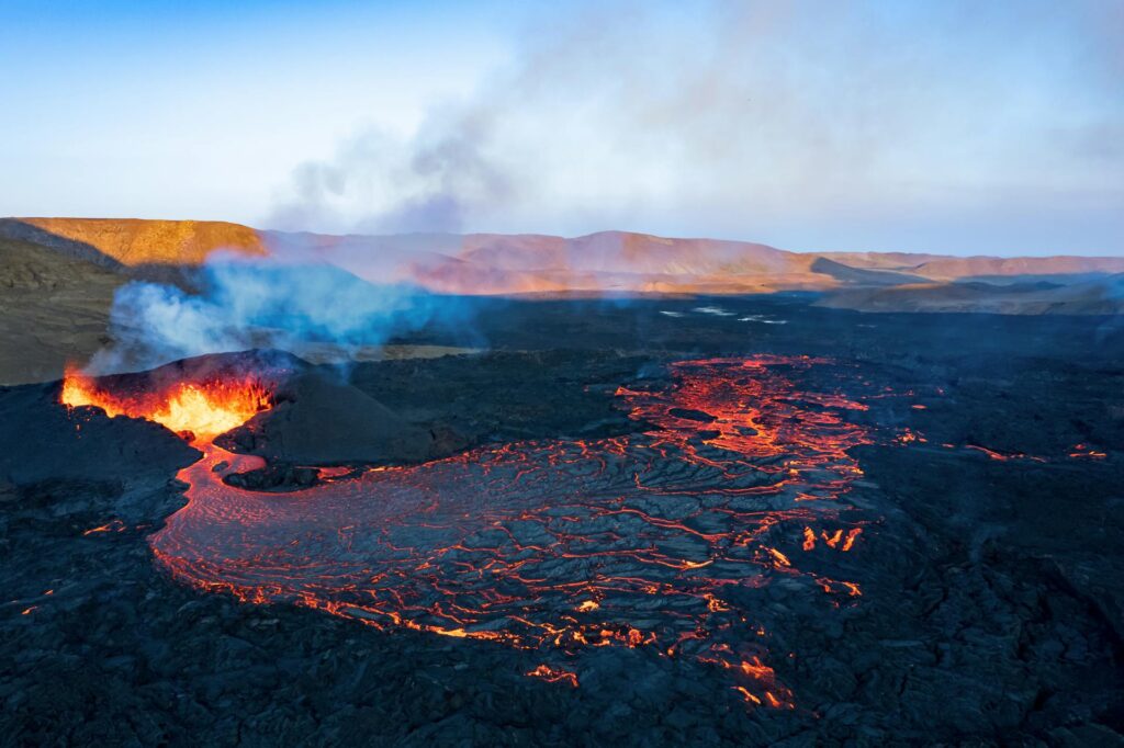
- Kilauea: Kilauea is probably the most famous of all Hawaiian volcanoes. It’s one of the most active volcanoes on Earth and has been erupting frequently since 1983, though its last major eruption was in 2018. It’s located on the southeastern side of the Big Island and is a major attraction at Hawaii Volcanoes National Park.
- Mauna Loa: This massive volcano is the largest on the planet by volume. It covers more than half of the Big Island and has erupted 33 times since 1843. Its last eruption was in 1984, but it’s considered active and closely monitored.
- Hualalai: Located on the west side of the Big Island, Hualalai is less active but still poses a threat. The last time it erupted was in 1801, and experts predict it will erupt again in the future.
- Mauna Kea: Mauna Kea is a dormant volcano, but it’s a huge one! It’s actually the tallest mountain in the world when measured from its base on the ocean floor. While Mauna Kea hasn’t erupted in over 4,000 years, it’s still classified as a dormant rather than an extinct volcano.
- Kohala: This is the oldest of the five volcanoes and is considered extinct. It’s located in the northern part of the Big Island and doesn’t pose any risk.
2. Maui:
Maui is home to Haleakalā, a dormant volcano that makes up about 75% of the island. Its summit is a popular spot for sunrise views, and the surrounding park is a stunning example of volcanic landscapes.
3. Oahu:
Oahu’s famous landmarks, Diamond Head and Koko Head, are actually volcanic tuff cones. They haven’t erupted in hundreds of thousands of years and are considered extinct. While you won’t see any lava here, they’re still an impressive reminder of the island’s volcanic past.
4. Kauai:
Kauai is the oldest of the main Hawaiian Islands, and its volcanoes, such as Mount Waialeale, have been dormant for millions of years. Kauai’s rugged terrain and dramatic cliffs are the result of millions of years of erosion on these ancient volcanoes.
Understanding Hawaii Lava Zones: Let’s Look at the Big Island
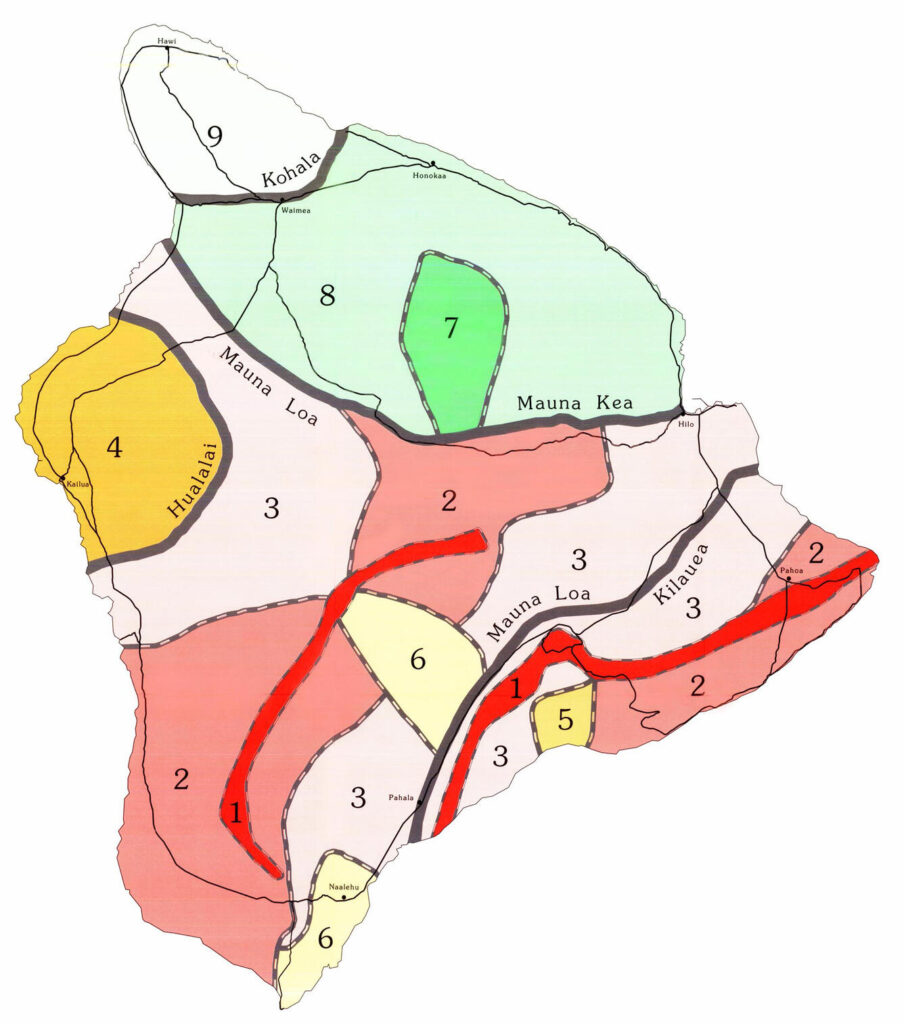
The concept of lava zones was established in 1974 by the United States Geological Survey (USGS) as part of a volcanic hazard mapping project. This classification system was designed to assess and categorize areas based on their potential risk of lava flow hazards. Given the Big Island’s active volcanic history and the regular eruptions of Kilauea and Mauna Loa, the need for a systematic approach to evaluating volcanic risks became apparent.
Hawaii lava zones are numbered from 1 to 9, with Zone 1 representing areas at the highest risk of volcanic activity and Zone 9 being the least vulnerable. The designation of these zones was based on historical lava flow patterns, proximity to volcanoes, and the frequency of past eruptions. The primary goal was to provide an accurate assessment tool for planning and development, allowing people to make informed decisions regarding land use and construction.
The categorization remains relevant today, not just for scientific purposes but also for practical applications in real estate and urban planning.
How Volcanic Activity Has Shaped Real Estate and Communities
Over the years, volcanic activity has left a lasting imprint on the Big Island’s landscape, housing market, and local communities.
Lava flows from eruptions—especially in the Puna District—have not only destroyed homes but also created entirely new stretches of land. In some cases, entire neighborhoods have been altered or erased from maps after lava inundated streets and properties. Perhaps the best-known example is the town of Kalapana, which was all but wiped out by eruptions in the late 1980s and early 1990s, forcing residents to abandon their homes and rebuild elsewhere.
This ongoing volcanic threat means some areas experience uncertain property values. Buyers and investors often weigh the natural beauty and unique living experience against the realities of risk, insurance limitations, and potential relocation. For those living in high-risk zones, the specter of future eruptions can affect everything from how they insure their property to how much lenders are willing to finance.
Yet, there are also upsides. The dramatic, ever-changing volcanic scenery draws adventurous homebuyers and tourists alike—a phenomenon you’ll see reflected in the demand for short-term vacation rentals and maverick homeowners looking for something you simply can’t find on the mainland. In a way, the volcanoes are both a challenge and a draw, shaping not just the land beneath our feet but also the character and rhythm of Big Island life.
Zone 1: The Highest Risk
Zone 1 includes areas that are directly over or near active volcanic rift zones. These are the most dangerous regions for lava flows. The Puna District, particularly lower Puna, falls into this category. In recent years, homes and entire neighborhoods in this zone have been destroyed by lava flows. Because of the high risk, property here is difficult to insure, and financing options are limited.
Subdivisions in Zone 1:
- Leilani Estates
- Kapoho (parts of it, not all — call for details)
- Kalapana Vacation Lots
- Royal Gardens
Zone 2: High Risk
Like Zone 1, areas in Zone 2 are still at high risk of lava flows but may be slightly further from active rift zones. Some parts of Puna and the southern slopes of Mauna Loa fall into this category. Real estate prices here tend to be lower than in safer zones, but buyers should be prepared for the challenges of securing loans and insurance.
Subdivisions in Zone 2:
- Black Sand Beach
- Nanawale Estates
- Hawaiian Beaches, Shores, and Parks
- Kapoho (parts of it — again, call for details)
- Kehena
- Puna Beach Palisades
- Kalapana Seaview Estates
- Kaimu-Makena Houselots
- Parts of Hawaiian Paradise Park (HPP)
Zone 3: Moderate Risk
Zone 3 represents a middle ground between high-risk and low-risk areas. Properties here are not directly threatened by volcanic rift zones but could still be impacted by lava flows from more distant eruptions. Lending and insurance options are more available, making real estate here a viable option for buyers looking to balance risk and affordability.
By understanding which subdivisions fall within each lava hazard zone, potential buyers can make informed decisions about the risks and benefits associated with purchasing property in the Puna District.
Zone 4-6: Low to Moderate Risk
Zones 4 through 6 gradually decrease in risk as the distance from active volcanic areas increases. These zones include popular regions like North Kona, Hilo, and parts of Waimea. Real estate in these zones offers greater stability in terms of insurability and access to financing.
Zone 7-9: Lowest Risk
Zones 7 through 9 are considered the safest areas in terms of volcanic activity. These zones are located on the oldest parts of the Big Island, where volcanic activity has not occurred for thousands of years. Most of the real estate development in areas like Kohala is within these zones, where land is more expensive due to the minimal risk.
Hawaii Lava Zones: South Kona District
When exploring the Hawaii lava zones specifically within South Kona, it’s important to be aware of the various subdivisions located within this picturesque yet geologically active region.
Subdivisions in South Kona
- Papa Bay: An area known for its awe-inspiring coastal views, nestled within the distinctive lava landscapes of the district.
- Miloli’i: Recognized as one of Hawaii’s oldest Hawaiian fishing villages, Miloli’i offers a glimpse into traditional island life amidst contrasting lava fields.
- Honomalino: A serene and lesser-known locale, famous for its secluded beaches and lush surroundings.
- Lani-Kona: This subdivision presents a blend of natural beauty and residential allure, offering a peaceful retreat.
- Kona Paradise: As the name suggests, this area is celebrated for its idyllic views and proximity to recreational activities.
- Coffee Farm Lots: Located within the rich volcanic soil, these lots are a charming option for those pursuing coffee cultivation or simply seeking a rural lifestyle.
- Opiihale: Known for its rugged landscapes and quiet ambiance, attracting those who cherish solitude and nature.
- Kaohe Estates: Offers expansive views and a sense of tranquility while being conveniently positioned to explore the rest of the district.
- Subdivisions South of Kiilae Farms: Encompasses a range of diverse communities, each offering unique characteristics shaped by the lava hazard zones.
Understanding the placements of these subdivisions within specific hawaii lava zones is crucial for residents and potential investors. Whether you’re drawn by the beauty, tranquility, or the thrill of living near volcanic activity, South Kona offers a unique lifestyle shaped by nature.
High-Risk Lava Hazard Subdivisions in South Kona
Several subdivisions in South Kona are classified within higher lava hazard zones due to their proximity to volcanic rift areas and younger lava flows. If you’re considering property here, it’s especially important to recognize which communities carry a greater degree of volcanic risk.
Some of the notable high-risk subdivisions in South Kona include:
- Papa Bay: Known for its spectacular ocean vistas but also situated near geologically active regions.
- Miloli‘i: Steeped in history as a traditional fishing village, this area remains close to dynamic lava zones.
- Honomalino: Offers peaceful seclusion and breathtaking beaches, though its location puts it within the upper tiers of lava hazard.
- Lani-Kona: A tranquil residential enclave, yet classified among the higher risk zones.
- Kona Paradise: True to its name for natural beauty, but buyers should be aware of its lava zone designation.
- Coffee Farm Lots: Positioned on fertile volcanic soil ideal for cultivation, but with added geologic risk.
- Opiihale: Draws those seeking solitude, but its landscape is a reminder of the area’s volcanic past.
- Kaohe Estates: Praised for open views and quiet living, yet still sits within zones of increased hazard.
- Subdivisions South of Kiilae Farms: This sweeping area comprises several neighborhoods, all lying within those lava zones considered more susceptible to future volcanic activity.
As always, confirming the latest lava hazard maps and consulting with local experts will help you weigh the balance between natural beauty and volcanic risk when choosing a property in South Kona.
Subdivisions in Hawaii Lava Zones in the District of Kau
Lava Hazard Zone 1
- Includes segments of the Hawaiian Ocean View Estates.
Lava Hazard Zone 2
- Encompasses Hawaiian Ocean View Ranchos.
- Covers the remainder of the Hawaiian Ocean View Estates.
- Incorporates all other minor subdivisions located in the district of Kau, extending from Hawaiian Ocean View Estates down to South Point.
This classification helps residents and potential homeowners understand the varying levels of lava hazard risk across different areas in Kau. By knowing which zone a specific subdivision falls into, they can make informed decisions regarding property investments and preparedness measures.
Exploring the Districts and Subdivisions of Hawaii’s Big Island
Hawaii’s Big Island is a diverse landscape, home to numerous districts, each offering unique charm and subdivisions. Here’s a detailed look at what you can expect:
North Kohala
A region rich in history and culture, North Kohala is where you can experience lush landscapes. It includes several subdivisions nestled in its scenic beauty.
South Kohala
Known for stunning beaches and resorts, South Kohala hosts subdivisions that cater to a laid-back yet luxurious lifestyle.
North Kona
Famous for its coffee and vibrant marine life, North Kona is a popular area with subdivisions that offer coastal views and tropical living.
South Kona
Home to picturesque bays and a slower pace, South Kona features subdivisions that boast expansive spaces and a serene environment.
North Hilo
With an abundance of waterfalls and fertile landscapes, North Hilo provides subdivisions that are fertile grounds for agriculture enthusiasts.
South Hilo
South Hilo is the heartbeat of cultural and economic activity on the island, with subdivisions lining its bustling streets and serene suburbs.
Hamakua
Once dominated by the sugar industry, Hamakua now features sprawling landscapes with subdivisions that are perfect for those seeking rural tranquility.
Puna
Puna offers a lush, rainforest-like setting. Its subdivisions are often nestled within this vibrant greenery, ideal for nature lovers.
Kau
The southernmost district, Kau, is a place of rugged beauty and resilience, home to subdivisions that allow for a more adventurous lifestyle.
Each district is a tapestry of communities and environments, showcasing the natural wonder and rich cultural heritage of the Big Island. Whether you’re seeking adventure, relaxation, or a blend of both, there’s a place here that calls to everyone.
Why Are Hawaii Lava Zones Important?
Even though the lava zones were created over four decades ago, they are still widely used and highly relevant for several reasons:
- Ongoing Volcanic Activity: The Big Island’s landscape continues to be shaped by active volcanoes. Kilauea, for instance, erupted in 2018, causing significant damage to properties in lower Puna. Hawaii lava zones help residents and potential buyers understand the risks associated with living on a volcanic island.
- Emergency Planning and Preparedness: The State uses Hawaii lava zones as part of its emergency planning. In the event of an eruption, evacuation protocols and safety measures are influenced by these zones. They also help in risk assessment for public infrastructure like roads, schools, and hospitals.
- Real Estate and Insurance: Most importantly, Hawaii lava zones play a critical role in real estate transactions, lending, and insurance. The higher the lava zone, the greater the risk, which directly affects a property’s insurability, financing, and overall market value.
Staying Protected: Proactive Insurance Steps in Hawaii Lava Zones
Safeguarding your investment in high-risk Hawaii lava zones isn’t a one-and-done process—it demands ongoing vigilance and adaptability. As the insurance landscape continues to evolve, here’s how you can make sure your coverage keeps up:
- Review Policies Regularly: Insurance terms, coverage limits, and premiums can change over time. Revisit your policy annually and after any significant changes in volcanic activity.
- Keep Up with Market Shifts: Stay informed about shifts in the insurance market, including updates from Lloyds of London and similar providers who specialize in high-risk areas.
- Explore Public Programs: Investigate state or federally backed assistance programs that might offer supplementary coverage or more favorable premium rates, especially as private insurers fluctuate in availability.
- Maintain Accurate Documentation: Ensure your property records and valuations are current. This can streamline claims, help you maintain adequate coverage, and speed up any future financing processes.
- Consult with Local Experts: Local insurance agents familiar with Big Island risks can help you tailor your coverage to Hawaii’s unique environment—don’t hesitate to leverage their experience.
By staying proactive and adaptable, buyers can better navigate the ever-changing realities of insuring property in Hawaii lava zones—turning these volcanic vistas into lasting, secure investments.
Community Preparedness and Local Infrastructure
Before you fall in love with a property in zones 1 or 2, take a close look at how resilient the community really is. Not all neighborhoods are created equal when it comes to dealing with volcanic hazards. Some communities have robust emergency response plans, active neighborhood watch groups, and regular safety drills—while others may be less prepared.
Infrastructure is another key factor. Check the condition and maintenance of access roads, particularly since lava flows have a habit of disrupting major routes in and out. Reliable utilities—electricity, water, and especially communication systems—aren’t always a given in these zones. Ask about the availability and response time of emergency services, as well as alternative routes in case of an eruption.
Consider chatting with residents and local officials to learn how past eruptions were handled and whether investments have been made in disaster preparedness. It’s wise to be proactive; knowing what safety nets you have in place can give peace of mind and strengthen your confidence as a Big Island buyer.
Zoning Regulations and Building Code Requirements
Prospective buyers should pay close attention to zoning laws and building codes that apply to zones 1 and 2. These high-risk Hawaii lava zones are subject to additional land-use restrictions established by both Hawaii County and the State. Regulations may dictate not only where you can build, but also the types of materials allowed, structural reinforcements required, and even access routes for emergency evacuation.
In these areas, local authorities might require enhanced foundation designs or specific roofing materials to withstand volcanic hazards. Plans may be reviewed more rigorously, and additional permits might be necessary. Be prepared for possible restrictions on lot subdivision or home additions, as well.
It’s also wise to consult with professionals familiar with Hawaii County’s planning department as well as licensed architects or builders who have experience building in high-risk zones. Their insights can help ensure your dream home is both compliant and resilient—protecting your investment for years to come.
Smart Building Choices for Lava and Fire Resilience
If you’re still game to build in zones 1 or 2—and hey, many are, enchanted by panoramic views and gentle tradewinds—it’s smart to think like a local architect with a survival instinct. Not all materials and designs will hold up to Pele’s fiery temperament, but some choices can bolster your odds.
Best Materials for the Job
- Reinforced Concrete & Steel: Forget about traditional wood framing; concrete and steel structures hold up much better against intense heat and stray embers.
- Metal Roofing: Asphalt shingles? Not in these parts! Opt for standing-seam metal roofing, which resists heat and fire better, and is less likely to become debris.
Fire-Resistant Siding: Fiber-cement panels, brick, or stone veneer are strong choices that shield against both fire and radiant heat.
Savvy Architectural Designs
- Elevated Foundations: Building on piers or columns gives you extra time and a slim chance of redirecting slow-moving lava. It also helps protect against flooding from heavy island rain.
- Modular and Moveable Homes: Hawaiian ingenuity includes homes you can relocate if the volcanic threat ramps up. Modular designs make this easier, offering flexibility if conditions become dicey.
- Strategic Landscaping: Wide gravel buffers, firebreaks, and low-flammability native plants offer a first line of defense. Keep landscaping neat and minimal around the home to slow the spread of both fire and lava.
- Clear Access Routes: Plan driveways and entry points wide enough for emergency vehicles and evacuation. When minutes matter, an open exit can be a lifesaver.
Embracing these construction strategies won’t make your property invincible, but they will give you a fighting chance—and a little extra peace of mind as you savor those unbeatable Big Island sunsets.
Smart Strategies for Long-Term Planning in Volcanic Areas
Successfully investing or living in Hawaii’s lava-prone regions takes more than luck—it calls for a proactive, well-informed approach. Here are a few strategies homeowners and investors can use to navigate the unique landscape:
- Revisit Your Risk Assessment Regularly: The volcanic landscape is dynamic, so it’s wise to stay up-to-date on activity reports and hazard maps issued by the US Geological Survey. Keep an eye on scientific guidance and local news to make informed decisions if conditions change.
- Spread Out Your Investments: If you’re looking at real estate purely for investment, consider diversifying across several Hawaii lava zones or even on other islands. This can help cushion the portfolio against the impacts of an eruption or sudden shifts in market demand.
- Design for Resilience: When designing or upgrading a home, choose materials and layouts that can better withstand the hazards unique to volcanic zones. Elevated foundations, metal roofing, and fire-resistant landscaping can make a meaningful difference.
- Stay Plugged into the Community: Get involved in local disaster preparedness groups and attend public meetings. Communities that work together are often better prepared for emergencies and recover more quickly—a real plus for long-term property values.
- Review Insurance Annually: Work with reputable insurers such as Lloyds of London, and don’t assume last year’s rates or coverage will still apply. Make it a habit to review policies annually to ensure you have adequate protection if circumstances change.
By treating risk management as an ongoing part of your ownership strategy—and staying flexible as new information emerges—you can safeguard your investment while enjoying all the rewards that come with life in one of the world’s most remarkable volcanic regions.
What to Watch for When Inspecting Existing Homes in Hawaii Lava Zones
If you’re touring existing homes in high-risk Hawaii lava zones, a careful inspection is your best friend. Focus on these critical points:
- Structural Integrity: Look for homes built with sturdy, fire-resistant materials. Reinforced concrete, tile roofs, and minimal use of wood help guard against heat and ash.
- Recent Safety Upgrades: Check if the property has up-to-date lava flow mitigation features—things such as raised foundations or firebreaks. Has the home been recently renovated to meet local codes for volcanic risk?
- Foundation and Drainage: Assess the foundation for cracks or shifting—signs of seismic activity. Effective drainage systems can help prevent problems from heavy rains or ashfall.
- Ventilation and Air Quality: Make sure there’s adequate ventilation to help keep out volcanic gases, especially sulfur dioxide, which can drift downwind from active vents.
Don’t hesitate to bring in a licensed home inspector familiar with Hawaii’s unique landscape. Experts with experience in volcanic regions (like those recognized by ASHI or InterNACHI) can spot vulnerabilities typical to the area, ensuring you know exactly what you’re buying before you sign on the dotted line.
Emergency Planning: How to Safeguard Your Investment in Hawaii Lava Zones
Owning real estate in high-risk Hawaii lava zones calls for more than just due diligence—it demands a proactive approach to emergency preparedness and evacuation planning. Here are the essential strategies every buyer should consider before making the leap:
- Know Your Escape Routes: Familiarize yourself with the local evacuation routes mapped out by Hawaii County Civil Defense. Make a habit of reviewing any updates, as volcanic activity can quickly alter safe paths in and out of your neighborhood.
- Develop a Personal Emergency Plan: Draft a detailed family emergency plan. This should include communication protocols, a designated meeting point, and a “go-bag” packed with essentials like documents, medications, and basic supplies.
- Home Access for First Responders: Design your property’s driveways and entrances to be easily accessible by emergency vehicles. Wide, unobstructed paths not only improve your own evacuation but also ensure timely assistance should you ever need it.
- Stay Plugged In: Set up alerts through the local Civil Defense and USGS Hawaiian Volcano Observatory—both offer real-time notifications about volcanic activity and evacuations. Staying informed means you’ll have a crucial head start if an emergency unfolds.
- Tap Into Community Networks: Join local homeowner groups or neighborhood associations. These communities often organize information sessions and preparedness drills, and they can serve as a valuable source of support and updates if an emergency strikes.
- Participate in Volunteer and Education Initiatives: Get involved with local volunteer teams or take part in safety workshops often led by organizations like the Red Cross or local fire departments. These programs are designed to equip residents with the knowledge and resources needed to weather any volcanic event.
By actively preparing and staying engaged with local resources, buyers can turn the challenge of living in lava hazard areas into an opportunity for heightened readiness and peace of mind. That way, you’ll be able to enjoy the Big Island’s unique landscapes with greater confidence and security.
Why Due Diligence Matters in Lava Hazard Zones
Given these unique risks, conducting thorough research and due diligence is absolutely essential when considering property in Hawaii lava zones 1 and 2. Buyers should be aware of the following challenges before moving forward:
- Insurance Hurdles: Options for homeowners and hazard insurance in these high-risk zones are restricted, often leading to higher premiums and limited coverage. Not all insurers operate in lava hazard areas, and it pays to compare different companies and read the fine print.
- Financing Obstacles: Traditional mortgages and construction loans can be difficult to secure. With many lenders opting out of these markets, buyers may find themselves relying on limited government-backed programs or facing steeper down payment requirements—often at least 20%.
- Ongoing Changes: Lending and insurance policies can change rapidly in response to volcanic activity. Staying updated on the latest developments is crucial.
Because of these factors, it’s vital to explore all your options, carefully review the terms of insurance and financing, and consult with professionals familiar with Big Island real estate. A little extra homework now can save you major headaches down the road, ensuring your investment is both protected and well-informed.
Disclosure Requirements for Sellers in High-Risk Hawaii Lava Zones
Sellers have a legal obligation to inform prospective buyers about any known volcanic hazards associated with their property, especially in Hawaii lava zones 1 and 2. This includes disclosing past lava flows, potential eruption risks, and any impacts these factors may have on insurability or ability to obtain financing.
Before finalizing your purchase, be sure to review all seller disclosures thoroughly and ask for clarification if anything is unclear. Full transparency helps you make an informed investment—and ensures that both parties meet their legal responsibilities.
Consulting Legal Experts: Safeguarding Your Investment
Another step not to overlook is seeking guidance from legal professionals experienced in Hawaii’s high-risk real estate markets. These experts can help you navigate the complex landscape of land use restrictions, disclosure requirements, and zoning regulations unique to volcanic regions.
Why does this matter? Purchasing property in Hawaii lava zones often involves unique contractual clauses, easements, and potential liabilities that don’t appear in less risky settings. A knowledgeable real estate attorney can review all documents to ensure you understand the implications, protect you from unexpected costs, and make sure you’re fully compliant with local laws. Their advice may also be invaluable when it comes to negotiating terms or resolving disputes that are specific to owning land in dynamic, geologically active areas.
With these precautions in place, you can approach your investment with greater confidence and peace of mind.
What Do Experts Predict About Ongoing Volcanic Risk?
Experts who study Hawaiian volcanoes agree on one thing—the Big Island’s volcanic activity isn’t going anywhere anytime soon. Both Kilauea and Mauna Loa remain active, and while scientists can track patterns, predicting the exact timing or intensity of future eruptions is still a challenge. The dynamic nature of these volcanoes means residents and property owners should always be prepared for the possibility of change.
Thankfully, advances in technology—think upgraded seismic networks, satellite imagery, and real-time gas monitoring—are improving how quickly scientists at the USGS and other agencies can detect early signs of unrest. These new tools provide better early warning systems, which means more time for people to respond if an eruption is on the horizon.
It’s also important to note that not all areas face the same level of risk. Places classified within Hawaii lava Zones 1 and 2 remain at the greatest risk for future lava flows and sudden changes in land use or accessibility, making them hotspots for both scientific attention and practical caution for anyone considering living or investing there.
Environmental Considerations in Hawaii Lava Zones
Beyond the practical concerns of insurance and financing, it’s important to weigh the environmental implications of living or building in lava hazard zones 1 and 2. These regions are not only susceptible to volcanic activity, but they also play host to sensitive ecosystems—think native forests, bird habitats, and rare plant life that have adapted to thrive in the dynamic landscape.
Volcanic eruptions and flowing lava can reshape land and disrupt natural habitats. Development in these zones may increase runoff, impact native species, or displace wildlife. Even small changes to the land—like clearing brush, paving driveways, or putting up fences—can have a ripple effect on local flora and fauna.
If preserving Hawaii’s natural beauty is part of your dream, factor in these potential impacts. Building responsibly and staying mindful of the island’s unique environment will help ensure that your piece of paradise remains vibrant for generations to come.
The Role of the Hawaii Volcano Observatory
Next, let’s talk about how volcanic risks are monitored and managed in real time. The Hawaii Volcano Observatory(HVO), part of the US Geological Survey, plays a crucial part in keeping both residents and officials in the loop about volcanic hazards. Their scientists keep a close watch on seismic activity, gas emissions, ground deformation, and other volcanic clues using high-tech equipment spread across the islands.
Thanks to this nonstop monitoring, the HVO can spot early warning signs of new eruptions and provide timely alerts—vital for evacuation planning, road closures, and public safety announcements. Their data-driven reports are also a key resource for government agencies, helping shape everything from local building codes to broader disaster response strategies. In short, the HVO’s work allows Hawai‘i’s communities and leaders to make informed, proactive decisions—keeping people safe and property as protected as possible in such a dynamic volcanic environment.
Discover More About Hawaii Lava Zones
Curious about lava hazard zones and looking for reliable information? Access expert insights and detailed data by visiting the United States Geological Survey’s comprehensive resource. This site is your go-to destination for understanding the intricacies of lava hazards:
Access the information here: USGS Lava Zones
Dive deep into interactive maps, current data, and expert articles to enhance your knowledge about volcanic risks and safety measures.
A Closer Look at Lava Zone Maps: Interpreting Boundaries and Map Currency
It’s important to understand that lava zone boundaries aren’t precise lines drawn in the sand—they’re more like gradual transitions based on how lava flows have behaved historically. Since volcanic activity doesn’t follow perfect borders, these zones blend into each other rather than stopping abruptly. The zones were originally mapped out using data on past eruptions and patterns observed over time, but volcanic landscapes are always changing, sometimes in subtle ways that don’t get picked up immediately.
What Goes Into Lava Zone Mapping?
The current lava hazard map for the Big Island, prepared by the US Geological Survey and revised in 1987, divides the island into nine zones, ranked from 1 (highest hazard) to 9 (lowest). These zones are primarily based on the location and frequency of both historic and prehistoric eruptions—relying on written records, Hawaiian oral traditions, and geological mapping of ancient flows. The map also factors in the larger topographic features that influence where lava will likely travel. For example, the hills behind Ninole sit high above the surrounding slopes of Mauna Loa, making them much less vulnerable to lava flows—even though they’re grouped within the same hazard zone as their lower-risk neighbors.
Gradual Boundaries, Local Variations
It’s worth noting that the change in risk from one zone to the next is typically gradual—often stretching over a mile or more—rather than a sudden jump. Within a single lava zone, the actual level of hazard can vary dramatically on a very local scale. The risk generally drops the farther you get from volcanic vents, but local topography can create pockets of higher or lower risk that a broad zone map can’t capture. Determining those finer details often requires in-depth, site-specific studies and up-to-date data.
What the Zones Don’t Show
While the primary focus is on lava flow risk, it’s also important to remember that other volcanic hazards—like tephra fallout (volcanic ash), ground cracking, or land settling—aren’t specifically mapped but tend to be most intense in the same high-risk lava zones.
Bottom line: lava zone maps are invaluable tools for understanding broad patterns of volcanic hazard, but they’re only one piece of the puzzle. For the most accurate picture, especially when evaluating a specific property, it’s smart to dig deeper and consider more localized studies, along with recent data and imagery.
What’s Ahead: Volcanic Activity and Real Estate Prospects
Looking down the road, the dynamic relationship between Hawaii’s volcanoes and its real estate isn’t going anywhere. Scientists universally acknowledge that volcanic activity on the Big Island will continue—after all, Kilauea and Mauna Loa aren’t in retirement anytime soon. While geologists at the USGS keep their eyes on the seismic screens, the timing and scope of the next big eruption remain mysterious. The only certainty is that the Big Island will keep growing… sometimes dramatically, and sometimes, unfortunately, at the expense of existing neighborhoods.
Innovations and Evolving Risks
The good news? Advances in volcano monitoring technology—think drones, satellites, and improved predictive models—are buying residents and property owners more time to react when Pele stirs. Early warning systems have come a long way, so communities in higher-risk zones (like 1 and 2) can stay ahead of sudden changes. But it’s also clear that living near the action means accepting some unpredictability: property access can shift overnight, and certain areas may face recurring challenges.
Real Estate: What Buyers and Owners Should Expect
Let’s talk property values. When Madame Pele reminds the island she’s boss, nearby home prices can dip, financing tightens, and insurance carriers may take a cautious step back (or charge you handsomely for sticking around). Yet there’s a flip side: some buyers are drawn to these zones for the lower initial costs and the undeniable uniqueness of living at the edge of creation.
Going forward, here are a few tips for those considering their options:
- Stay Informed: Regularly review your property’s risk level. Updates from the Hawaiian Volcano Observatory and local news sources are essential.
- Diversify Investments: If you’re investing, spreading risk across several districts—or even islands—can help balance potential losses.
- Smart Construction Choices: If you’re building, consider materials and designs that boost resilience against heat, ash, and shifting land.
- Community Involvement: Connect with neighborhood groups and stay plugged in to county-level emergency planning. A strong, prepared community is your best insurance of all.
- Flexible Insurance Plans: Insurance requirements and availability change with each eruption cycle. Work with carriers familiar with Big Island realities and revisit your coverage often.
In short, the future of real estate on the Big Island is a dance between risk and reward, shaped by ancient traditions and modern technology. With knowledge, planning, and a touch of island flexibility, it’s possible to thrive—even on volcanic ground.
Essentials for Safety, Preparedness, and Sustainable Living in Hawaii Lava Zones
Living in an area shaped by volcanoes requires a practical approach to both safety and environmental responsibility. Whether you’re thinking about building a new home or buying existing property in one of Hawaii lava zones, there are some tried-and-true strategies you’ll want to keep in your back pocket.
Smart Building and Property Planning
- Choose Tough Materials: In places where lava is part of the landscape, everyday building materials just won’t cut it. Go for reinforced concrete, steel framing, or other fire-resistant options to help your property stand up to heat and flames.
- Elevate When Possible: Consider designing homes on stilts or raised platforms. Not only does this provide a buffer against lava flow, but it also buys valuable time for evacuation if the need ever arises.
- Keep It Mobile: If permanence is less of a concern, modular and pre-fab homes are popular choices. These can sometimes be relocated if new hazards emerge.
- Create Defensible Space: Think of landscaping as your property’s first line of defense. Maintain wide, clear zones free of brush or clutter to slow down advancing lava and minimize fire risk.
Staying Prepared and Informed
- Know the Drill: Familiarize yourself with local evacuation routes and keep an emergency kit stocked with essentials—think water, food, important documents, and protective gear.
- Request a Thorough Inspection: Before sealing the deal on any home purchase, have the structure assessed for volcanic hazard readiness (roof type, venting, structural stability, and proximity to known flow paths).
- Tap Into Local Knowledge: Talk with neighbors, local contractors, and planning offices—folks who’ve lived through eruptions are a goldmine of practical information.
- Engage With the Community: Join neighborhood associations or volunteer groups focused on disaster preparedness. Being part of a resilient community makes all the difference when challenges arise.
Building with the Future in Mind
- Prioritize Sustainability: Choose building methods and materials that are gentle on the surrounding ecosystem—think solar panels, low-impact foundations, and native landscaping.
- Encourage Resilience: Home designs that can adapt as conditions change—like those with removable or upgradable components—help communities bounce back faster after volcanic events.
- Invest Long-Term: Responsible construction and thoughtful land management not only protect your investment, they help sustain vibrant, stable communities for generations to come.
Balancing natural beauty with real-world practicalities is part of life on the Big Island. By blending safety, community preparedness, and sustainable development, homeowners and homebuyers can enjoy peace of mind while making the most of island living.
Sustainable and Safe Building in Hawaii Lava Zones
If you’re considering building or buying in lava-prone regions, it’s vital to prioritize sustainable and resilient construction—think of it as giving your property its own suit of armor against the Big Island’s ever-changing landscape. Here’s how to protect your investment (and maybe sleep a little easier at night):
Building Smarter, Building Safer
- Sturdy Materials are Key: Opt for fire- and heat-resistant building materials such as reinforced concrete or metal. These types of construction can stand up far better to both the heat and debris from volcanic activity than traditional wood structures.
- Elevate Where Possible: If the landscape allows, consider building on raised foundations or stilts. Elevated homes can sometimes reduce the risk of direct lava inundation and give you extra minutes to take action in an emergency.
- Flexible Design: Modular or easily reconfigurable layouts aren’t just trendy—they’re practical. Homes designed with flexibility in mind can adapt or be moved if conditions change unexpectedly.
Smart Landscaping Decisions
- Defensible Space: Keep landscaping well-managed and create wide, clear buffers around your home. This helps slow the advance of fire or lava, and reduces fuel for airborne embers. Go for gravel or lava rock over lush, flammable foliage near the house.
- Accessible Driveways: Make sure roads, driveways, and property entrances are wide enough for emergency vehicles—and clear of overhanging branches or other obstacles that might slow a quick exit.
Savvy Buying Tips
- Inspect Thoroughly: Before purchasing, have a professional check that existing structures meet safety and resilience standards. Not all homes are created (or maintained) equally, especially in ever-active zones.
- Consult the Pros: Local architects, builders, and even long-time residents can provide invaluable tips and warnings—it’s worth tapping into that community wisdom before making big decisions.
Why It Matters
Adopting these building practices isn’t just about protecting your own slice of paradise. Sustainable, safe development preserves the island’s natural beauty and helps create communities that can withstand whatever Madame Pele sends our way. A bit of planning now leads to homes that last, neighborhoods that bounce back, and—importantly—a thriving Hawaii for future generations.
Emergency Planning in High-Risk Hawaii Lava Zones
If you’re considering calling one of high-risk Hawaii lava zones home, a solid emergency plan isn’t just a suggestion—it’s a must-have. Preparation today can make all the difference tomorrow (especially with Pele’s unpredictable schedule).
Key Steps for Your Emergency Plan:
- Stay Connected to Updates: Bookmark the USGS Hawaii Volcano Observatory and sign up for county emergency alerts. Staying informed about volcanic activity helps you react quickly when it matters most.
- Map Your Routes: Familiarize yourself with official evacuation routes and create a household plan. Decide on a safe meeting spot outside the hazard area in case your group gets separated.
- Build Your Emergency Kit: Have a go-bag ready. Essentials? Think water, non-perishable food for several days, medications, sturdy shoes, masks (N95s help with ash), eye protection, battery-powered radio, flashlights, and a copy of important documents.
- Inspect and Prepare Your Property: Walk the perimeter periodically—look for signs of structural wear or cracks made worse by shifting ground. Secure heavy furniture, reinforce doors and windows, and know how to safely shut off utilities if needed.
- Review Insurance Details: Not all homeowner policies cover volcanic events, which can be a pricey lesson in hindsight. Talk to your provider—some national brands like State Farm or Allstate may offer specialized riders depending on your location.
- Engage with Your Community: Join neighborhood safety meetings or online groups to coordinate preparedness efforts, share timely information, and help neighbors with mobility or transportation concerns. Remember, good communication can help the entire community respond faster and safer during a crisis.
Thinking ahead and building an actionable emergency plan gives some peace of mind—something especially valuable when you live in paradise with a fiery twist.
Government Agencies: Planning, Protection, and Recovery
The state and local governments have also woven a sturdy net beneath Big Island residents. That means:
- Early Warning and Emergency Response: From sirens to radio updates, the government maintains robust warning systems and clear evacuation routes. Temporary shelters are prepped to provide safe havens when the ground rumbles.
- Recovery Support: After an eruption, programs ranging from low-interest rebuilding loans to direct financial aid can ease the path back to normalcy. Comprehensive land use regulations and building codes are enforced to reduce future risks, while rebuilding efforts focus on safer, more sustainable homes.
- Ongoing Research: The Hawaii Volcano Observatory—an arm of the USGS—continuously monitors volcanic activity, blending cutting-edge science with local knowledge. Their data not only drives public policy, but helps communities make informed choices about land use and personal safety.
Insurance Guidance: For those navigating the tricky world of property insurance in high-risk zones, state-backed initiatives step in to help connect homeowners with the right coverage and steer them through the paperwork.
The Impact of Hawaii Lava Zones on Lending and Insurance
Perhaps the most significant way Hawaii lava zones influence real estate is through their effect on lending and insurance. For properties located in Zones 1 and 2, obtaining a mortgage is often a complex and challenging process. Many lenders are hesitant to finance homes in high-risk Hawaii lava zones due to the potential for property destruction. When loans are available, they often come with stricter terms, higher interest rates, or larger down payments.
Current Financing Landscape
Many lending institutions have completely eliminated their financing programs for these risk zones. This has created a significant barrier for potential buyers and builders. However, not all hope is lost. The Federal government offers a program through Rural Housing Development, providing an alternative for those determined to invest in these areas.
While this option does exist, it’s important to note that qualifying for such programs can be challenging. Eligibility is often limited by income, property location, and specific property requirements set by the USDA Rural Development guidelines. Additionally, even if a buyer qualifies, the selection of eligible homes in high-risk lava zones is often quite narrow, and the approval process may take longer than conventional loans.
Despite these hurdles, the Rural Housing Development program remains a vital pathway for buyers who are committed to living in these dynamic landscapes. For many, it’s the only feasible way to secure financing when traditional lenders have stepped back from the market.
Conventional Financing Challenges
For conventional financing, most institutions require a minimum of 20% down payment to lend on a property in these high-risk zones. This requirement, coupled with the stricter loan terms, underscores the financial commitment needed to secure a home in Zones 1 and 2.
Navigating the financing options in these areas demands careful consideration and planning, but understanding these requirements can help you make informed decisions in the real estate market.
Insurance Hurdles
Insurance, too, is a major hurdle for homeowners in these zones. Most national insurance companies will not provide coverage for homes in Lava Zones 1 and 2, as the risk is deemed too great. Instead, homeowners often need to rely on the Hawaii Property Insurance Association (HPIA), which offers coverage specifically for high-risk volcanic areas. However, HPIA policies can be expensive, and coverage options are limited.
Effect of Hawaii Lava Zones on Real Estate Prices
Hawaii lava zones also have a direct influence on land and home prices. In general, the higher the risk of volcanic activity, the lower the price of land. For example, properties in Zone 1 can be significantly cheaper than similar properties in lower-risk zones. This price discrepancy makes buying in high-risk zones appealing to some buyers, especially those looking for affordable land or off-grid living options. However, the challenges of obtaining insurance and financing, as well as the risk of property destruction, must be carefully considered.
The market in lava-prone areas is far from static. After significant volcanic eruptions, property values in high-risk zones often decrease as buyers become more aware of the inherent risks. Yet, as time passes and memories of eruptions fade, the allure of inexpensive land in Hawaii’s stunning landscapes draws new interest, sometimes spurring market recovery. This cyclical nature means that opportunities—and pitfalls—can arise for both buyers and sellers depending on timing and prevailing sentiment.
In contrast, real estate in Zones 7 through 9 tends to be far more expensive, as these areas are considered much safer. Buyers in these zones enjoy greater security, easier access to insurance, and fewer obstacles to securing a mortgage, making these properties highly sought after.
Managing Volcanic Risk: Diversification and Resilient Building Approaches
Given the complex landscape of Hawaii lava zones, savvy investors and homeowners often look for proactive ways to manage risk. Two of the most effective strategies are diversifying real estate holdings and choosing building methods that can better withstand volcanic hazards.
Diversifying Investments for Stability
Rather than concentrating all resources in one high-risk zone, spreading investments across multiple locations can help mitigate exposure. For example, holding properties both within and outside of higher-risk Hawaii lava zones—including areas like Hilo, Waimea, or even other Hawaiian islands—balances potential rewards and lessens vulnerability to sudden volcanic events. Just as portfolio diversification shields against market volatility on the stock market, diversifying real estate assets cushions against localized disruptions, whether they stem from eruptions or insurance changes.
Building Resilient, Adaptable Structures
Choosing to develop properties with resilience in mind is another smart move. This can be as simple as using sturdy, lava-resistant materials such as reinforced concrete or steel roofing, or incorporating flexible architectural designs that are easier to modify or repair after an event. Many property owners also consider modular or elevated structures, which can sometimes help minimize damage. Consulting resources from organizations like the American Institute of Architects or FEMA can provide guidance on best practices for building in hazard-prone areas.
The Benefits Over Time
By combining diversification and resilient building techniques, investors and homeowners can not only protect their own assets but also contribute to the broader stability of their community. A portfolio that spans risk levels, paired with thoughtful, robust construction, positions you to weather both figurative and literal storms.
Together, these strategies allow you to pursue opportunities in Hawaii’s unique real estate market with greater confidence, whether you’re buying for lifestyle, investment, or future resale.
Exploring B2B Resources and Opportunities in Hawaii Real Estate
Hawaii’s real estate market offers a wealth of opportunities for business-to-business (B2B) interactions. Here’s how you can tap into these resources and possibilities effectively:
Comprehensive Support and Resources
For professionals involved in Hawaii real estate, accessing a variety of helpful resources can significantly enhance operational efficiency and market success.
- Educational Materials: Guides and online courses from renowned institutions can help agents and businesses stay ahead of industry trends and regulatory changes.
- Technology Tools: Platforms like Zillow and Redfin offer data analytics and tools to streamline property analysis and client interactions.
Building Strong Networks Through Referrals
Referrals play a pivotal role in B2B interactions. Establishing relationships with other real estate professionals and related businesses can lead to a steady influx of potential clients.
- Referral Programs: Partner with local and national agents through established networks like the National Association of Realtors (NAR) to expand your client base.
- Local Business Alliances: Collaborate with local businesses, such as interior designers or moving services, to create mutually beneficial referral systems.
FAQs About Hawaii Lava Zones: Big Island
What is the purpose of lava zones on the Big Island?
Lava zones were created to assess the risk of volcanic activity in various regions of the Big Island. They help in emergency planning, real estate transactions, and insurance decisions.
How do Hawaii lava zones affect real estate prices?
Properties in higher-risk lava zones (Zones 1 and 2) tend to be cheaper due to the potential for volcanic destruction, while land in lower-risk zones is more expensive but easier to insure and finance.
Can I get a mortgage for a home in Lava Zone 1?
It can be challenging to secure a mortgage for homes in Lava Zone 1, as many lenders view the risk as too high. When loans are available, they often come with stricter terms.
Is it safe to buy property in Lava Zone 2?
While it’s possible to buy property in Lava Zone 2, buyers should be aware of the risks and challenges, including difficulty obtaining insurance and financing.
Why are homes in Lava Zone 9 more expensive?
Homes in Lava Zone 9 are more expensive because they are in the safest areas in terms of volcanic activity, making them highly desirable and easier to insure.
What insurance options are available for homes in high-risk Hawaii lava zones?
Homeowners in high-risk zones often need to rely on specialized insurance providers like the Hawaii Property Insurance Association (HPIA), but policies can be expensive and limited.
Living near Hawaii’s volcanoes offers a mix of thrill, beauty, and risk. It’s not for everyone, but for those who love the power of nature and don’t mind the challenges, it can be incredibly rewarding. Understanding the Hawaii lava zones, the location of the volcanoes, and the lifestyle around them is key to making the best choice for your family and future. So, whether you’re looking to buy, rent, or just curious, I hope this gave you a good sense of what to expect. Aloha!
Need Expert Advice on Safe Investment Areas?
Relevant Blogs
What you need to know about Hawaii Property Tax